Report on the results of radiocarbon datings from the Wadi Sura area, Gilf Kebir, southwestern Egypt
by
Carlo Bergmann, Christian Kny and Christian Philipp
1. Palaeoclimatic setting
In his essay “The geomorphological and palaeoclimatic framework of prehistoric occupation in the Wadi Bakht area” (in: J. Linstädter, U. Tegtmeier (eds), Wadi Bakht - Landschaftsarchäologie einer Siedlungskammer im Gilf Kebir, Africa Praehistorica 18 (2005), pp. 51 - 65) S. Kroepelin proposes four distinct palaeoclimatic phases which prevailed in the south eastern Gilf Kebir during the Holocene:
a.) hyper-arid climate until 9,300 BP (8,400 BC)
b.) a moderately arid summer rain regime yielding 100-150 mm of annual precipitation and about four major rainfall events per century in the period between 9,300 and 5,400 BP (8,400 – 4.300 BC); Early Holocene
c.) a unique climatic transition at 5,400 BP (4,300 BC) when “.. a regime of secular monsoonal-convective summer rains… was succeeded by a west-wind induced type of climate with occasional winter rainfalls with steady rains… (that is, a shift) from an African monsoonal type of climate to a Mediterranean winter rainfall pattern with quantitatively lower amounts but more continuous rainfall during winter.” (Ibidem, p. 60); “terminal phase of the Holocene pluvial (5,500 – 4,800 BP/4,400 – 3,500 BC)” (Ibidem, p. 62); Mid Holocene
d.) a return of extremely arid conditions indicated by a “… definite end of playa-type accumulations.” (Ibidem, pp. 58, 60) at circa 4,500 BP (3,300 BC)
The period between 9,300 and 4,800 BP (8,400 – 3,500 BC; points b. + c.) comprises the Neolithic Subpluvial, the so called Holocene Wet Phase.
2. Our findings
2.1 14C datings
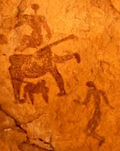
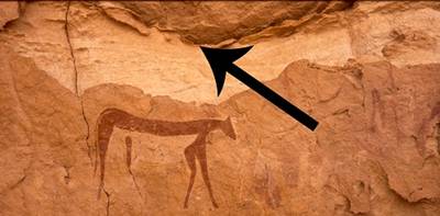
According to Andras Zboray´s catalogue of rock art seventeen major art-embellished rock shelters were found since 2002 in the vicinity of the Cave of the Swimmers (WG 52; Andras Zboray classification) and the Foggini-Mestekawi Cave (WG 21). Apart from WG 21 and WG 52, five of the seventeen localities bear images of “headless beasts”, (figure 1) whilst another one is decorated with “… the famous pair of negative hand prints on the ceiling” (Andras Zboray, email of 1/4/2010). Concentrating on these two categories of images or “index archetypes”, both of which are prominent features at WG 52 and WG 21, we selected WG 32; WG 49; WG 61, WG 73/A and neighbouring WG 72 for brief investigations.
figure 1: two “headless beasts” and human figures at WG 73/A
Unexpectedly, at four of these sites and at WG 52 (Cave of the Swimmers) organic material was found, the 14C datings of which are presented in table 1. (The tableau also includes a dating obtained from the left ulna of a skeleton found in the vicinity of Gebel Babein. This dating will be discussed in the main report “On the origins of the Egyptian Pantheon”.)
|
site
|
age
|
material dated
|
|
1.) WG 32 (Andras 1) |
BP 7,141 +/- 43 calBC 6,080 – 5,920
|
Ostrich eggshell from the entrance to the rock shelter |
|
2.) WG 73/A-5 (Andras 10-5)
|
BP 6,890 +/- 27 calBC 5,790 – 5,723
|
Charcoal from a fire place
|
|
3.) WG 73/A-2 (Andras 10-2)
|
BP 6,786 +/- 28 calBC 5,713 – 5,638
|
Charcoal from the same fire place
|
|
4.) WG 73/A-1 (Andras 10-1)
|
BP 6,300 +/- 35 calBC 5,350 – 5,210 |
Ostrich eggshell from top of the same fire place |
5.) WG 52(Cave of the Swimmers)
|
BP 5,589 +/- 28calBC 4,485 – 4,354
|
wooden peg from the cave´s roof
|
|
6.) WG 61 Altar cave (Andras 8-2)
|
BP 5169 +/- 36 calBC 4,050 – 3,820 |
Bone frag-ments found at the foot of the sacrificial altar
|
|
7.) WG 72 (Andras 09) |
BP 4,802 +/- 26calBC 3,646- 3,525 |
wooden peg from the cave´s roof |
|
8.) Sanddunes in the vicinity of Gebel Babein (Dune field 2009/10-1)
|
BP 5,246 +/- 27calBC 4,230 – 3,975 |
Human skeleton (see picture 5 in Advance Report) |
Table 1: results of radiocarbon datings from the Wadi Sura area, Gilf Kebir, southwestern Egypt
2.2 Samples and their place of discovery
2.21 WG 32
An ostrich eggshell was found at the foot of the sandstone hillock immediately to the left of the entrance of rock shelter WG 32 (figure 3). It was partly embedded in the sediment, with its upper section protruding from the ground which was scattered with Neolithic artefacts (figure 2). It is assumed that the eggshell is a.) part of the existing archaeological context and that b.) this context can be loosely associated with the artists who may have camped or settled at the site and who created the faint rock paintings with which the interior of the shelter is embellished.
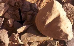
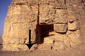
figure 2: ostrich eggshell protruding from the sediment at WG 32 (courtesy of Philipp Dahmer)
figure 3: entrance to WG 32 (courtesy of Philipp Dahmer)
2.22 WG 73/A
Figure 4
reveals the stratigraphy of a fire place which was found on a hill terrace above
WG 73/A. ![]() Just under a
sandstone slab
Just under a
sandstone slab ![]() that was lying on
top of a thin layer of sediment covering the fire place
remains, one of the participants discovered an
ostrich eggshell
(stratum No. 1; WG 73/A-1).
Beneath
that was lying on
top of a thin layer of sediment covering the fire place
remains, one of the participants discovered an
ostrich eggshell
(stratum No. 1; WG 73/A-1).
Beneath ![]() the egg shell lie
an estimated seven strata of charcoal
the egg shell lie
an estimated seven strata of charcoal ![]() . Samples were taken from two strata
(No. 2 + No. 5; WG 73/A-2
+ WG 73/A-5).
According to the 14C-test supervisor, the age difference of 104 years that
exists between
WG 73/A-5
and
WG 73/A-2,
is, due to a sigma 2.7 value,
statistically significant. This means that the divergence is not caused
by random errors. Instead, it is safe to say that the two samples are of
different age thus, two clearly differentiated periods of use are verified.
. Samples were taken from two strata
(No. 2 + No. 5; WG 73/A-2
+ WG 73/A-5).
According to the 14C-test supervisor, the age difference of 104 years that
exists between
WG 73/A-5
and
WG 73/A-2,
is, due to a sigma 2.7 value,
statistically significant. This means that the divergence is not caused
by random errors. Instead, it is safe to say that the two samples are of
different age thus, two clearly differentiated periods of use are verified.
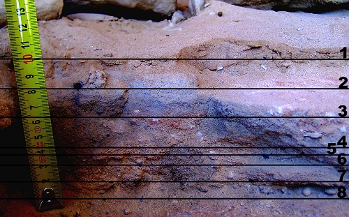
figure 4: stratigraphy of a fire place found above WG 73/A. (courtesy of Philipp Dahmer)
2.23 WG 52 - Cave of the Swimmers
The wooden peg shown in figure 5 was discovered in a crack located in the cave´s roof, 3.30 metres above the ground and only a little way above the painting of a cow. (figure 6) The find fits in neatly with rock paintings which depict pots and other utensils hanging from the roofs of shelters (as for instance in CC 21; Andras Zboray classification).
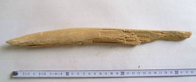
figures 5 + 6: Cave of the Swimmers - wooden peg found in a crack above the painting of a cow.
(figure 5: courtesy of Philipp Dahmer)
Wooden pegs are common features in cave roofs as
reported by Mark Borda, Andras Zboray and others. ![]()
Since the 1930´s, WG 52 has been visited by a vast number of tourists and also by a few Egyptologists, archaeologists, pre-historians and rock art specialists. Kuper and his associates frequented the site several times. On one occasion he made a TV-documentary there with a film team. Why had none of the thousands of visitors bothered to report about the clearly visible wooden stick which, weighing 120 grams, measures 33.5 cm in length and max. 2.9 cm in diameter? Had all these people simply not noticed this important item?
2.24 WG 61 – Altar Cave
Much to my astonishment I (Carlo) noticed a sacrificial altar at WG 61. The altar is adorned with engravings of the fauna belonging to the period of the hunter gatherers. (figure 7; see chapter 3.2).
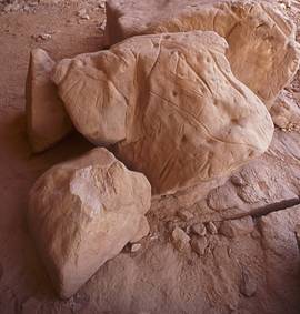
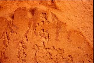
figure 7: sacrificial altar at the foot of which bone fragments were found
figure 8:
sandstone ![]() hook partly
vandalizing the depiction of a “headless beast” (colour enhanced)
hook partly
vandalizing the depiction of a “headless beast” (colour enhanced)
The item which Le Quellec et al. describe as “De gros blocs rocheux isoles jonchent le sol…” (J. Le Quellec, P. and P. de Flers: Peintures et gravures d´ avant les pharaons du Sahara au Nil, Seleb 2005, p. 188) without attempting to interpret its use, attests to the possible ritual or even early religious function of WG 61 which, in parts, is ornamented with “sacred” or “mythical” iconography.
![]() Into the shelter´s northern rock face I
(Carlo)
noticed
Into the shelter´s northern rock face I
(Carlo)
noticed ![]() that the rock had
been carved
that the rock had
been carved ![]() out to form an
upward pointing butt that can function as a sandstone hook from which to suspend
items. This sandstone hook partly vandalizes the depiction of one of the
three(?)
“headless beasts” (figure
8) that occur in this
locality. Does such vandalism indicate use of the cave by people who lived at a
time when the mythical-religious meaning of some of the Wadi Sura iconography
was no longer part of a binding cultural heritage? Thus, was the
out to form an
upward pointing butt that can function as a sandstone hook from which to suspend
items. This sandstone hook partly vandalizes the depiction of one of the
three(?)
“headless beasts” (figure
8) that occur in this
locality. Does such vandalism indicate use of the cave by people who lived at a
time when the mythical-religious meaning of some of the Wadi Sura iconography
was no longer part of a binding cultural heritage? Thus, was the ![]() shelter and its
imagery no longer seen
shelter and its
imagery no longer seen ![]() as a place
of a sacred ritual practice? The 14 C date belonging to the bone fragments
(figure 9)
found at this site, below the sediment at the
foot of the sacrificial altar, seems to support
such a view. However it also might be that very lately,
say a few hundred years ago, the sandstone hook was
made by passing Tubu herders
as a place
of a sacred ritual practice? The 14 C date belonging to the bone fragments
(figure 9)
found at this site, below the sediment at the
foot of the sacrificial altar, seems to support
such a view. However it also might be that very lately,
say a few hundred years ago, the sandstone hook was
made by passing Tubu herders ![]() to hang up one of their girbas.
to hang up one of their girbas.
figure 9: bone fragments found on the bedrock covered by a five centimetres
thick layer of sediment at the foot of the sacrificial altar of WG 61
2.25 WG 72
Thanks to the awareness of a member of our party a wooden peg similar to the one found in the Cave of the Swimmers but much thinner, was discovered in WG 72. (figure 10; this fellow also found the items listed as Nos. 4, 5 and 6 in table 1) Inserted into a fissure of the sandstone at breast height it most certainly served the same purpose as the peg referred to in chapter 2.23.
figure 10: wooden peg (courtesy of Philipp Dahmer)
3. Discussion
One of the major remains from the era of prehistoric occupation of the Wadi Sura region is the rock art and owing to its staggering diversity, it seems logical to interpret the dating results presented above, not only within their archaeological context but in a much larger framework.
3.1 Linking our Wadi Sura chronology with climatic change
a.) The first stratigraphic evidence ever, brought to light in the Wadi Sura area was obtained from a small settlement site (fire place) discovered on a hill terrace of WG 73/A. (see chapter 2.22)
Datings derived from samples recovered from three of the eight WG 73/A-strata (see figure 4) and from site WG 32 (figure 2) confirm that the area below the western cliffs of the Gilf Kebir, from around BP 7,150 to BP 6,300 (calBC 6,000 – 5,200), could support sedentary or semi-sedentary human occupation for at least 800 years. This span of time falls fairly well into Kroepelin´s period of a moderately arid summer rain regime yielding 100-150 mm of annual precipitation and about four major rainfall events per century.
b.) The dating of the wooden peg which was found inserted into a crack of the Cave of the Swimmers´ ceiling (WG 52) coincides roughly with the beginning of the terminal phase of the Holocene pluvial (5,500 – 4,800 BP/4,400 – 3,500 BC) when an African monsoonal type of climate was succeeded by Mediterranean winter rainfall patterns. However, as it still lies, by a few years only, within the confines of Kroepelin´s Early Holocene it may indicate that the period of sedentary or semi-sedentary human occupation in the Wadi Sura area lasted for at least 1,500 instead of 800 years, from circa BP 7,150 to BP 5,550 (calBC 6,000-4,400). To clarify this question further archaeological studies are suggested.
In this context it should however, also be noted that the dating of the wooden peg from WG 52 (BP 5,589 +/- 28 (calBC 4,485 –4,354)) is contemporary with the datings obtained from human corpses of the Neolithic cemeteries discovered at Gebel Ramlah: a.) burial 3: BP 5,555 +/- 60 (calBC 4,460 – 4,340), b.) burial 4: BP 5,535 +/- 35 (calBC 4,390 – 4,310), c.) burial 5: BP 5,740 +/- 50 (calBC 4,690 – 4,630), d.) burial 10: BP 5,610 +/- 45 (calBC 4,490 – 4,360). According to the excavators the individuals buried at Gebel Ramlah represent “trans-huming pastoralists”. (M. Kubusiewicz, J. Kabacinski, R. Schild, J. D. Irish, F. Wendorf: Discovery of the first Neolithic cemetery in Egypt´s western desert. in: http://findarticles.com/p/articles/mi_hb3284/is_301_78/ai_n29125471/pg_4/?tag=cont and page 5 and by the same authors: Burial practises of the Final Neolithic pastoralists at Gebel Ramleh, Western Desert of Egypt in: http://www.britishmuseum.org/research/online_journals/bmsaes/issue_13/kobusiewicz.aspx) Gebel Ramlah is situated circa 550 kilometres to the east-southeast of the Wadi Sura area.
c.)
The bone fragments which were discovered on the bedrock covered by a five
centimetres thick layer of sediment at the foot of the sacrificial altar at
WG 61
can be assigned to the period during which a winter rainfall regime already
persisted for circa 300 years. We consider these
relics to be indicative of ![]() sacrificial rituals
and offerings or other cult activities which took place well after the
installation of the altar. Our view is supported by the
choice of motifs
sacrificial rituals
and offerings or other cult activities which took place well after the
installation of the altar. Our view is supported by the
choice of motifs ![]() engraved on this sacrificial stone.
(for details see main report)
engraved on this sacrificial stone.
(for details see main report)
d.) The wooden peg found in a crack of the roof of rock shelter ![]() WG
72
dates to the juncture where the terminal phase of the Holocene pluvial
was succeeded by the return of extremely arid conditions
(BP 4,800; calBC 3,500).
WG
72
dates to the juncture where the terminal phase of the Holocene pluvial
was succeeded by the return of extremely arid conditions
(BP 4,800; calBC 3,500).
3.2 Linking our Wadi Sura chronology with the settlement phases deduced by Kroepelin for the Gilf Kebir
Referring to Wadi Bakht, Kroepelin claims that its water resources “…have never been sufficient for permanent settlement in the connotation of years or decades or even generations with a few possible exceptions that may have occurred during the mid-Holocene playa phase when some open water may have persisted until the onset of the rains in the following year.” (Ibidem, p. 61) Therefore “... it is most likely that settlement during the entire early and mid-Holocene, or what has been called the `Neolithic wet phase´, was possible only temporarily during summer and autumn in the early Holocene, and during winter months during the middle Holocene... (as) there were also little chances to bridge the seasonal or episodic occupation from one year to the other by the use of wells...” (ibidem) Extending his dictum beyond Wadi Bakht, Kroepelin continues: “The unsuitable hydrological conditions for long-term stationary stays … also apply to the other valleys of the southeast Gilf Kebir.” (Ibidem) Finally, in line with this state of facts he concludes “...that the seasonal, periodic or episodic inhabitants of the Gilf Kebir were based at Jebel Ouenat... with its permanent water points and lush valleys.” (Ibidem, p. 62; underlining from us)
However, in Kroepelin´s view there seems to exist an exception: “A remarkable fact of the prehistoric occupation of the Gilf Kebir is the existence of a Late Neolithic in the 4th and 5th millennium BC. (5,000 – 3,000 BC) During that period, which was already marked by increasing aridity, human settlement elsewhere in the Egyptian part of the Eastern Sahara had already moved to the oasis depressions of Kharga, Dakhla, Farafra and Bahariya, or to the Nile or northern Sudan. In the southeast Gilf Kebir, however, the upper reaches of Wadi Baht and neighbouring Wadi al Akhdar were still used by prehistoric man, apparently even more intensely than during the generally more favourable early Holocene. (8,400 – 4,300 BC)… the faunal inventories of Wadi Bakht show a clear difference between these phases. While the faunal remains from the earlier phase are restricted to wild game such as antelope and gazelle, the later phase also include sheep or goat and cattle. This fact… led to the inference that the first inhabitants were hunter gatherers, and the later ones were pastoral groups, for the needs of which the altered conditions on the plateau provided a suitable habitat. An expansion of the settlement to the plateau during a phase of general climatic deterioration in the Eastern Sahara due to the retreating monsoonal rain seems surprising… Apparently, the quantitatively more significant monsoonal summer rains that were characteristic for the Early Holocene (9,300 – 5,300 bp/8,400 – 4,400 BC) typically fell during the day-time and resulted in lower amounts of grass growth on the plateau than the presumed winter rains characteristic for the terminal phase of the Holocene pluvial (5,500 – 4,800 bp/4,400 – 3,500 BC).” (Ibidem; underlining from us)
Thus, based on Kroepelin`s assessment, our samples from sites WG 61 and WG 72 which belong to the period between 4,000 to 3,500 BC, seem to represent remains of cattle pastoralists, whilst the three dates obtained from WG 73/A and the ones from WG 32 and WG 52 belong to the (earlier) era of the first hunter gatherer inhabitants. (Note however the comment regarding WG 52 in chapter 3.1 b)
Sidenote 1: Kroepelin´s assertion that human settlements, other than ecological retreats such as the Gilf Kebir and Gebel Uweinat had “…because of increasing aridity …moved to the oasis depressions …or to the Nile or northern Sudan during the 4th and 5th millennium BC…” must be treated with caution. Proof of the contrary comes from site Dune field 2009/10-1, human skeleton (table 1) which was found in the midst of an exceptionally large Neolithic settlement clustered along the shores of a former lake district, and which yielded an age of BP 5,246 +/-27 (calBC 4,230 – 3,975). The dating indicates that, even in low lands flanked by dunes and, further away, by stone age dune habitats of uncertain age (German: Siedeldünen) noticeable human habitation did exist during the period in question. Situated within sight of Gebel Babein, the settlement is 110 kilometres to the south-southwest of Wadi Sura and 80 kilometres to the north of Gebel Uweinat. By comparison:
figure 11: two fragments of a bowl found at Dune field 2009/10-1. Le Quellec et al.
published pottery of a similar kind (“Décor d´une poterie neolithique des Gilf Kebir”)
without revealing the approximate location of the place of discovery. (J. Le Quellec,
P. and P. de Flers: Peintures et gravures d´ avant les pharaons du Sahara au
Nil, Seleb 2005, p. 23, figure 15)
a.) The BP-age of 5,246 +/-27 (calBC 4,230-3,975) falls into the Badarian Period, but the grave good associated with the skeleton (a single bowl, figure 11) bears no resemblance with the pottery of this Upper Egyptian culture.
b.) The skeleton is circa 300 – 500 BP-years younger than those excavated in a Neolithic cemetery at Gebel Ramlah. (see M. Kubusiewicz, J. Kabacinski, R. Schild, J. D. Irish, F. Wendorf: Discovery of the first Neolithic cemetery in Egypt´s western desert. in: http://findarticles.com/p/articles/mi_hb3284/is_301_78/ai_n29125471/pg_4/?tag=cont and by the same authors: Burial practises of the Final Neolithic pastoralists at Gebel Ramleh, Western Desert of Egypt in: http://www.britishmuseum.org/research/online_journals/bmsaes/issue_13/kobusiewicz.aspx) Gebel Ramlah is situated circa 580 kilometres to the east-southeast of Dune field 2009/10-1.
c.) The skeleton is half a BP-millennium younger than the one discovered in the vicinity of Biar Jaqub (see Results of the Winter 2008/9 Bergmann-Böckli-Marai-4WD-trip to Gebel Uweinat, Advance Report on this website). The latter was dated to BP 5,716 +/- 46.
Thus, could it
be that water resources in the surroundings of
Dune field 2009/10-1
had
been sufficient not merely with regard to ![]() “…a few possible exceptions that may have
occurred during the mid-Holocene playa phase when some open water may have
persisted until the onset of the rains in the following year
(as described by Kroepelin),
but also, that these water resources had been sufficient …for permanent
settlement in the connotation of years or decades or even generations?” The
mere size of the
Dune field 2009/10-1 –
settlement
area seems to be indicative
“…a few possible exceptions that may have
occurred during the mid-Holocene playa phase when some open water may have
persisted until the onset of the rains in the following year
(as described by Kroepelin),
but also, that these water resources had been sufficient …for permanent
settlement in the connotation of years or decades or even generations?” The
mere size of the
Dune field 2009/10-1 –
settlement
area seems to be indicative ![]() of the
latter scenario.
of the
latter scenario.
By the way, in 1978 van Noten published 14C datings from ostrich eggshells associated with Neolithic surface material found at three sites in the plain north of Karkur Talh, Gebel Uweinat (site Pt 22: BP 3,510 +/-35; site Pt 24: BP 6,115 +/-70; site Pt 43: BP 4,305 +/-60). Sites Pt 22 and 43 are located at lower elevations than the older site Pt 24. ”The location of the sites in this plain seem to be correlated with a closed basin where the presence of water progressively decreased.” (F. van Noten, Rock art of the Jebel Uweinat. Linz 1978, p. 29) Van Noten´s limited data base suffices to support the assumption that Neolithic man occupied the northern lowlands encompassing Gebel Uweinat from at least BP 6,100 to BP 3,500.
3.3 Contesting Kroepelin´s proposal that the seasonal, periodic or episodic inhabitants of the Gilf Kebir were based at Jebel Ouenat.
We contest Kroepelin´s proposal for the following reasons:
3.31 No evidence of mythical Wadi Sura rock art themes at Gebel Uweinat
Wadi Sura lies at the hilly flanks of the western escarpment of the Gilf Kebir (figure 12), circa 10 minutes latitude north of Wadi Bakht and roughly 120 kilometres distant from it.
figure 12: “hilly flanks” of the Western Gilf Kebir viewed from top of the plateau
The locale ![]() contains
about two dozen caves and rock shelters of which the Cave of the Swimmers
(WG 52)
and the Foggini-Mestekawi Cave
(WG 21)
are the most prominent. The latter, being adorned with innumerable rock
paintings which so far, are of unrivalled significance, enigma and complexity,
is considered
contains
about two dozen caves and rock shelters of which the Cave of the Swimmers
(WG 52)
and the Foggini-Mestekawi Cave
(WG 21)
are the most prominent. The latter, being adorned with innumerable rock
paintings which so far, are of unrivalled significance, enigma and complexity,
is considered ![]() to be one of
the great discoveries in the Western Desert.
(M. Barta, Swimmers in the sand. Dryada 2010, p. 23)
The majority of this iconographic material seems to be concerned with mythical
and genealogical themes, “life-death-cycles”
(manifesting themselves in depictions of so called “headless beasts” and a
prototype of the goddess Nut(?) painted in
white)
and emotions deeply influenced by the sacred
(German: Ergriffensein durch das Heilige)
thus the purpose and scope of these depictions reaches far beyond the daily
struggle for existence. From this viewpoint
WG 21
immediately presents itself as a magnificent stage in which, once upon a time,
complex rituals were performed with the leading parts of these Neolithic
performances enacted by the spectacular panels of rock art themselves. Although
the meaning of the rock art may never be fully understood, it would not be
inappropriate to visualize
WG 21
as a stone age sanctuary(see
also M. Barta, Swimmers. op. cit., p. 98),
a shrine for worship created at the very dawn of religion.
to be one of
the great discoveries in the Western Desert.
(M. Barta, Swimmers in the sand. Dryada 2010, p. 23)
The majority of this iconographic material seems to be concerned with mythical
and genealogical themes, “life-death-cycles”
(manifesting themselves in depictions of so called “headless beasts” and a
prototype of the goddess Nut(?) painted in
white)
and emotions deeply influenced by the sacred
(German: Ergriffensein durch das Heilige)
thus the purpose and scope of these depictions reaches far beyond the daily
struggle for existence. From this viewpoint
WG 21
immediately presents itself as a magnificent stage in which, once upon a time,
complex rituals were performed with the leading parts of these Neolithic
performances enacted by the spectacular panels of rock art themselves. Although
the meaning of the rock art may never be fully understood, it would not be
inappropriate to visualize
WG 21
as a stone age sanctuary(see
also M. Barta, Swimmers. op. cit., p. 98),
a shrine for worship created at the very dawn of religion. ![]() (Such
ideas are of course at best, only approximations of what was going on in the
minds of these Neolithic people as it is simply not possible to fully understand
the complex religious beliefs of distant cultures, when looked at as they are,
from the lenses of ancient Egyptian
(Pharaonic)
religion, let alone from those of modern times.)
(Such
ideas are of course at best, only approximations of what was going on in the
minds of these Neolithic people as it is simply not possible to fully understand
the complex religious beliefs of distant cultures, when looked at as they are,
from the lenses of ancient Egyptian
(Pharaonic)
religion, let alone from those of modern times.)
However, if, as Kroepelin supposes, the people who embellished WG 21 with its mythical-sacred paintings thousands of years ago were based at Gebel Uweinat, depictions akin to “headless beasts” etc. should also exist at that remote mountain. Yet, although today Gebel Uweinat is fairly well researched, similar pieces of rock art (other than handprints which may indicate a trait in religious orientation that strongly refers to organized cult practices) have not yet been found there.
3.32 Further aspects indicating that a
(semi-)
sedentary ethnic group of hunter gatherers created
Wadi Sura´s mythical-sacred rock art ![]()
Thus far, the type of enigmatic rock art, so evidently loaded with mythical content and hidden sacred connotations of the kind displayed at WG 21; has not been found anywhere in the Western Desert except at the Wadi Sura area.
Only here, at WG 21 (Foggini-Mestekawi Cave), WG 52 (Cave of the Swimmers) and at a few other sites in the wider surroundings (WG 32, WG 44/B, WG 45/A, WG 49, WG 61, WG 73/A), do certain particular features of this unique religious pictorial canon repeat themselves. The localities concerned are scattered across an area of circa 120 square kilometres. The bare number of sites and their surprisingly extended spatial distribution alone, may suffice as proof of permanent settlement by a distinctive ethnic group that:
a.) had homogeneous cultural and religious practises
b.) whose cultural development had evolved into a unique perception of the sacred to which no other populace in the wider region had progressed. Thus, in all probability, the level of civilization (German: Kulturstufe) they attained may be regarded as a partly independent cultural achievement which surprisingly blossomed more or less exclusively in the Wadi Sura area.
As
indicated by the 14C-datings derived from incremental
samples taken from
WG 32
and
WG 52 and the three
samples taken from
WG 73/A ![]() , this
, this ![]() group of people,
group of people, ![]() who most likely consisted of hunter
gathers
who most likely consisted of hunter
gathers ![]() that had resided
in the Wadi Sura area for a significant length of time, may be considered as the
creators of those examples of rock art there, that are mythical-sacred in
character. Their artistic expressions
(German: Kunstäußerungen)
which by no means, can be imagined as the result of a mere few days work, were
that had resided
in the Wadi Sura area for a significant length of time, may be considered as the
creators of those examples of rock art there, that are mythical-sacred in
character. Their artistic expressions
(German: Kunstäußerungen)
which by no means, can be imagined as the result of a mere few days work, were ![]() painted or carved on the rock faces of
different Wadi Sura shelters during a period
painted or carved on the rock faces of
different Wadi Sura shelters during a period ![]() that lasted
circa 1,500 years, from around 6,000 – 4,400 BC.
that lasted
circa 1,500 years, from around 6,000 – 4,400 BC.
3.33 Excluding cattle pastoralists as creators of the mythical-religious type art at Wadi Sura
The remarkable accumulation of localities and their peculiar and elaborate decoration (only here, not at Gebel Uweinat) reveals that events, cult actions and rites which supposedly, were performed in the caves and rock shelters, were of great importance to those hunter gatherers. Why then, on the one hand, should tribal groups whose home was at Gebel Uweinat feel obliged to create such elaborate imagery loaded with complex meaning while passing by a comparatively unfamiliar wadi in a distant place? Why, on the other hand, did these groups not feel permitted to place a similar type of rock art with its divine symbolism on the shelters of their supposed home lands at Gebel Uweinat? Does this make sense? If anything, the pastoralists of the much later cattle period would have contributed their share of art by adding cattle- and cattle herders motifs to the already existing archaic Wadi Sura rock art in reflection of their daily life.
That these cattle herders who practised transhumance, were attracted by “holy sites” which had existed long before their times, possibly using them as a place of pilgrimage or Neolithic Mecca (see P. and P. de Flers, J. J. Le Quellec: Prehistoric swimmers in the Sahara. http//rupestres.perso.neuf.fr./page 76/assets/AC_, p.61) or as a mere shelter, is evidenced by relics of their presence dated to BP 5169 +/-36 (calBC 4,050 – 3,820) and BP 4,802 +/- 26 (calBC 3,646 – 3,525) respectively. (see table 1, consecutive numbers 6 + 7)
Sidenote 2:
It may well be that the art embellished Wadi Sura rock shelters ![]() attracted
cattle herders from far away,
attracted
cattle herders from far away, ![]() fulfilling the role
of staging points or
fulfilling the role
of staging points or ![]() of a Neolithic Mecca during
the yearly pasture-cycles. To
of a Neolithic Mecca during
the yearly pasture-cycles. To ![]() support the
possibility of such
support the
possibility of such ![]() religiously motivated
religiously motivated ![]() migrations we may cast a glance at
the far away Göbekli Tepe
temple in south-eastern Anatolia.
migrations we may cast a glance at
the far away Göbekli Tepe
temple in south-eastern Anatolia. ![]() Concerning this
stone age ceremonial centre which is estimated to be
circa 10,000 years old, Klaus Schmidt points
out that
Concerning this
stone age ceremonial centre which is estimated to be
circa 10,000 years old, Klaus Schmidt points
out that ![]() it could
draw worshippers from a ”cultural catchment area” of up to 200 kilometres in
radius, if essentially the same material culture and similar symbolism prevailed
in such an expanse.
(K. Schmidt. Sie bauten die ersten Tempel.
München 2008, p.252)
In the case of Wadi Sura
Schmidt´s
it could
draw worshippers from a ”cultural catchment area” of up to 200 kilometres in
radius, if essentially the same material culture and similar symbolism prevailed
in such an expanse.
(K. Schmidt. Sie bauten die ersten Tempel.
München 2008, p.252)
In the case of Wadi Sura
Schmidt´s ![]() model seems worth a look in detail
model seems worth a look in detail ![]() if for
instance, images
if for
instance, images ![]() (possibly
related to religious practises)
other than handprints of
uncertain age occur both at Gebel Uweinat and at the Gilf Kebir.
(possibly
related to religious practises)
other than handprints of
uncertain age occur both at Gebel Uweinat and at the Gilf Kebir.
To sum up: Both, the sheer number of these regionally
confined sites and the large amount of ![]() apparently
religious sacred-mythical imagery depicted in the rock art within them, which is
also carefully executed and rendered in a homogeneous style
apparently
religious sacred-mythical imagery depicted in the rock art within them, which is
also carefully executed and rendered in a homogeneous style ![]() speaks in
favour of authorship by a sedentary
speaks in
favour of authorship by a sedentary ![]() group of people
group of people ![]() . The creation of such a pictorial world
certainly was a time-consuming affair; an observation that by itself may also
imply the presence of a sedentary group. The reasons a.) why the sudden
occurance of religious imagery in question took place in the Wadi Sura area and
not at Gebel Uweinat and b.) why this event did not happen out of the blue, will
be discussed in brief in the next chapter and in the main report
(On the origins of the Egyptian pantheon).
. The creation of such a pictorial world
certainly was a time-consuming affair; an observation that by itself may also
imply the presence of a sedentary group. The reasons a.) why the sudden
occurance of religious imagery in question took place in the Wadi Sura area and
not at Gebel Uweinat and b.) why this event did not happen out of the blue, will
be discussed in brief in the next chapter and in the main report
(On the origins of the Egyptian pantheon).
3.34 Why did prehistoric man favour Wadi Sura and its surroundings? – Interpreting the Neolihic (Wadi Sura) cultural development in analogy to Braidwood´s “Hilly Flanks” concept (L. S. Braidwood, R. J. Braidwood, B. Howe, C. A. Reed, P. J. Watson (eds.): Prehistoric Archaeology along the Zagros Flanks. Oriental Institute Publications 105, Chicago 1983)
3.341 Climatic, topographic and geomorphological determinants as preconditions for socio-cultural development and change in artistic expression
As
confirmed by our findings, the first
(continuous)
Neolithic habitation phase in the Wadi Sura area occurred between 6,000
and 4.400 BC. ![]() To date, the noticeable clusters of hunter
gatherer settlement sites of this period which are situated in the wider
vicinity of the Cave of the Swimmers, are unparalleled in the Gilf
Kebir; a fact which suggests that Kroepelin was misled by evidence from a
spatially restricted region, viz. the south-eastern Gilf, when he assumed
that the seasonal, periodic or episodic inhabitants of the Gilf Kebir were based
at Jebel Ouenat... with its permanent water points and lush valleys. But why
did Neolithic man feel attracted by this particular stretch of hilly ground
which lies only a stone´s throw away from the steep western escarpment of the
Gilf Kebir? Referring to the so called “Hilly Flanks” concept which
rejects the idea that the Neolithic Revolution began in the valleys and oases of
the Near East proposing instead, that the new mode of life originated rather in
regions blessed with an abundance of game species which, whilst being hunted,
were at the same time, domesticated by man, i.e. the Hilly Flanks of
Breadsted´s Fertile Crescent
(at the fringes of the Taurus and
Zagros mountain ranges), the following explanation for
the Wadi Sura area is offered:
To date, the noticeable clusters of hunter
gatherer settlement sites of this period which are situated in the wider
vicinity of the Cave of the Swimmers, are unparalleled in the Gilf
Kebir; a fact which suggests that Kroepelin was misled by evidence from a
spatially restricted region, viz. the south-eastern Gilf, when he assumed
that the seasonal, periodic or episodic inhabitants of the Gilf Kebir were based
at Jebel Ouenat... with its permanent water points and lush valleys. But why
did Neolithic man feel attracted by this particular stretch of hilly ground
which lies only a stone´s throw away from the steep western escarpment of the
Gilf Kebir? Referring to the so called “Hilly Flanks” concept which
rejects the idea that the Neolithic Revolution began in the valleys and oases of
the Near East proposing instead, that the new mode of life originated rather in
regions blessed with an abundance of game species which, whilst being hunted,
were at the same time, domesticated by man, i.e. the Hilly Flanks of
Breadsted´s Fertile Crescent
(at the fringes of the Taurus and
Zagros mountain ranges), the following explanation for
the Wadi Sura area is offered:
Evidently, something new, both
- at the hilly flanks of the Taurus and the Zagros mountains (a new way of life) and
- in the Wadi Sura area (a new expression of the sacred in pictorial art)
had been created. Regarding the latter region, 14-C datings from WG 32, WG 52 and WG 73/A suggest that (circa) 6,000 BC marks the dawn of more favourable climatic conditions in the Wadi Sura area lasting for the next 1,500 years. Nevertheless, as a result of a persistently unstable (climatic) balance between moist and dry intervals interrupted by longer periods of severe aridity, Neolithic people in this part of the (former) desert steppe/savannah, with the exception of those living in the lush valleys of Gebel Uweinat, had become increasingly aware of their fragile existence. Thus, the harsh environment and the uncertainties and pressures resulting therefrom, may have evoked a change in the prevailing socio-religious concepts of death and rebirth as well as in the perception of the sacred. Owing to extremely fortunate circumstances, environmental conditions in the Wadi Sura area facilitated favourable living conditions for much more than a millennium; a span of time in which the mental change in question could be artistically explored without haste until “final solutions” of this development were projected on rock faces. From the viewpoint of this isolated socio-cultural development as seen in the Wadi Sura rock art, the region, in comparison to the much larger scale of the Fertile Crescent and in particular, to the climatically more favoured Gebel Uweinat as the nearest point of reference, may be envisioned as a “hilly flanks region en miniature”
Yet, at this stage of our study it is worthwhile to take another look at the Wadi Bakht stratigraphy where, in section 82/2, K. Neumann and St. Nußbaum noticed a “..joint occurrence of Ziziphus, Maerua and Tamarix in 380-430 cm depth (which) indicates somewhat wetter conditions around 6,870 +/- 65 bp (5,750 +/- 60 BC)”. (S. Kroepelin, op. cit., p. 59) Note that these somewhat wetter conditions correlate roughly with the beginning of the settlement phase in Wadi Sura at around BP 7,150 (circa 6,000 BC). Kroepelin continues: “Maerua crassifolia probably has populated the slopes (of Wadi Bakht) in low density.” (Ibidem) Referring to Walter (H. Walter, Vegetation und Klimazonen. Stuttgart 1979) he then points out: “In this context, however, observations in the desert south of Cairo with an annual precipitation of 25 mm have to be taken into account… Given that 40 % of the rainfall there collects in the deepest parts of the terrain which make up about 2 % of the area, the plants at these privileged sites receive the same amount of water as those on the plain would only obtain with a rainfall of 500 mm/year” (Ibidem) which amounts to a twentyfold potentiating effect.
To these findings observations from Tell es-Sultan/Jericho may be added. The site is situated 230 metres below sea level and receives 100 mm annual precipitation. In comparison, neighbouring Al-Quds/Jerusalem lying 800 metres above sea level, reports 500-700 mm of annual rain fall. Despite the arid conditions at Tell es-Sultan, the capacity of the spring suffices to supply more than 50.000 people with water. (see K. Schmidt, op. cit, p. 27f.) The case of Tell es-Sultan shows that, notwithstanding little rainfall in lowlands, topographic and geomorphological features in combination with higher precipitation rates on nearby uplands, may allow for an ecologically favoured region in the wider vicinity of the latter (here: circa 22 kilometres) thus inviting habitation. Does this imply that the Hilly Flanks in which Wadi Sura lies, were, once upon a time, an ecological retreat for plants, wildlife and humans? A study of the terrain with Google Earth which reveals the topography of the region would seem to confirm this as does Kroepelin´s somewhat wetter conditions in Wadi Bakht and our other findings.
So far, we have dealt with the period between 6,000 and 4,400 BC, the first Neolithic habitation phase in the Wadi Sura area. But what about the era during which “a west-wind induced type of climate with occasional winter rainfalls with steady rains” prevailed (5,500 – 4,800 BP/4,400 – 3,500 BC)? As shown above, this epoch is linked with 14 C datings from WG 61 and WG 72 which indicates that at that time, nomadic cattle herders frequented the Wadi Sura area signifying that sufficient vegetation for humans and their herds must have existed. Although Kroepelin states “…the climate in.. (this) part of the Eastern Sahara has been relatively arid during the entire Holocene…” (Kroepelin, op. cit., p. 60; see however, the contradicting evidence put forth in sidenote 1) the Wadi Sura region, even in the period between 4,400 – 3,500 BC, seems to have been a favoured habitat for cattle herders. Pending the much awaited 14-C dating results from localities surrounding the Gilf Kebir, we may, for the time being, speculate that the western cliff of the Gilf Kebir functioned as an orographic zone, its continuous wall of cliffs 1050 metres above sea level forcing the humid air transported by a west-wind, prevalent in the climate of that period, to rise and to condense causing increased rainfall and thus, ensuring the livelihood of the Wadi Sura ecosystem at the times of the cattle pastoralists.
Sidenote 3: As indicated by many old cattle trails, these pastoralists also ranged the flat top of the Gilf Kebir in order to exploit its sparse grasslands (see also Kroepelin, op. cit., p. 62) However, notwithstanding some exceptions such as Wadi Abd el-Malik and Wadi Hamra (including expansion of settlements to the plateau), it seems almost certain according to the distribution of archaeological remains, that the surface of the plateau, compared to the Wadi Sura area, offered only sub-optimal conditions for livelihood and larger settlement activities.
Referring to the Hilly Flanks concept mentioned above, we may, even during the times of the cattle pastoralists, visualize the Wadi Sura area as a Hilly Flanks region in small scale, i.e. as an environmental refuge, which in the field of pictorial art, prospered and progressed more than other regions of the Gilf Kebir.
Topographic and geomorphological features made the Wadi Sura region a preferred retreat for 6th and 5th millennium (BC) hunter gatherers. The area may be visualized as having been “dry savannah”; a mosaic of sparse hill woods, gallery forests flanking wadis that seasonally bore water, grass and moor vegetation. Because of its favourable micro-environment, the area, probably from the onset of the Neolithic Wet phase, may have been imbued with spiritual meaning. Later, at the end of the 5th and in the 4th millennium BC, after several sacred places had been designated by hunter gatherers, it also may have become a Mecca for nomadic cattle herders.
3.342 Cultural responses to the climatic setting
Unlike
the surface on top of the plateau, the hilly flanks to the west of the Gilf
Kebir were intensively utilised by prehistoric man. Apparently, such preference
resulted in
cultural achievements so far, unprecedented in the Gilf. It led to a unique
advancement in the shaping of rock art motifs and to an intensification of
trends towards clear and explicit expressions of the sacred
(as exemplified for instance, by
the sudden and exclusive occurrence of the so called “headless beasts”).
Yet there is no simple solution to find out what precisely triggered and guided
this progress. Whilst the sensitive observer finds himself marvelling at the
miracles presented to him at such sites as
WG 21,
he (lacking a suitable
analytical-comparative perspective) finds himself
confined to a position where he may approach the ![]() evolution of
this Neolithic cultural and art-historical development which much later,
manifested itself in the depictions of gods and goddesses of the Pharaonic
pantheon (see M. Barta:
Swimmers. op. cit. pp. 47ff. pp. 87ff.), with the help
of hermeneutic-historical inquiries only.
evolution of
this Neolithic cultural and art-historical development which much later,
manifested itself in the depictions of gods and goddesses of the Pharaonic
pantheon (see M. Barta:
Swimmers. op. cit. pp. 47ff. pp. 87ff.), with the help
of hermeneutic-historical inquiries only.
At any rate, in the absence of evidence to the contrary, it (up til now) seems certain that the roots of this visual arts form originated, developed and prospered in the Wadi Sura area proper; not at Gebel Uweinat, not at the oases of the Western Desert and their surroundings and not in the Nile valley or anywhere else in the desert. But how can the cultural mechanism be explained through which formerly practised forms of pictorial representations of the sacred (in ancestor worship, shamanistic traditions or totemism) were abandoned and replaced by a till then, unfamiliar variant? And how, as of that date, could precisely this variation affect the coining of “religious brands” and deity images for millennia to come?
As manifested in the WG 21 rock art, reflections about death and rebirth, whilst being shifted into another, a new direction, also changed the way of the corresponding (cultic and) artistic expression, and from then on, images of a judging, punitive deity emerged (as exemplified by the occurrence of “headless beasts”). Seemingly, gods or goddesses began to determine the conditions for rebirth which formerly, stone age man may have considered arbitrary or not even existing. Do we vision here a novel religious concept which, cum grano salis, in its appendant imagery, mirrors ethical principles in association with personal failure and transgression? Exactly these intrinsic references and connotations may have provoked a cultural achievement i.e., an innovation and advancement in the field of pictorial art, which one witnesses with amazement at WG 21.
Sidenote 4:
The image of a chieftain who smites the heads of his enemies which Barta
considers ![]() the earliest attestation of
the earliest attestation of ![]() such a motif
in the Egyptian hemisphere (M. Barta: Swimmers. op. cit., pp. 35, 37), suggests
that at the time the depiction was made, new forms of social differentiation had
emerged which seemingly, substituted previously existing egalitarian social
structures. If it is true that culture and religion merely reflect social
conditions and practises so that, in the end, mankind tends to create its gods
according to its needs (see Ludwig Feuerbach, Gesammelte Werke, vol. 7,
Theogonie. W. Schuffenhauer (ed.), Berlin 1969, pp. 31 ff), then the religious
archetype of the “punishing deity” is nothing but
such a motif
in the Egyptian hemisphere (M. Barta: Swimmers. op. cit., pp. 35, 37), suggests
that at the time the depiction was made, new forms of social differentiation had
emerged which seemingly, substituted previously existing egalitarian social
structures. If it is true that culture and religion merely reflect social
conditions and practises so that, in the end, mankind tends to create its gods
according to its needs (see Ludwig Feuerbach, Gesammelte Werke, vol. 7,
Theogonie. W. Schuffenhauer (ed.), Berlin 1969, pp. 31 ff), then the religious
archetype of the “punishing deity” is nothing but ![]() a result of
a result of ![]() the
cultural-religious sublimation of a physically explorable reality which, at that
stage of the Neolithic, manifests itself in the
role of the chieftain with a mace and a defeated enemy (figure 13). From
this perspective it comes to no surprise to find the
the
cultural-religious sublimation of a physically explorable reality which, at that
stage of the Neolithic, manifests itself in the
role of the chieftain with a mace and a defeated enemy (figure 13). From
this perspective it comes to no surprise to find the ![]() “the smiting of the
enemy” motif
(at WG 21)
on a rock art panel
“the smiting of the
enemy” motif
(at WG 21)
on a rock art panel ![]() associated
with depictions of its metaphysical complement such as
the “headless beast”
(interpreted as an early divine creature
associated
with depictions of its metaphysical complement such as
the “headless beast”
(interpreted as an early divine creature ![]() ; see M. Barta: Swimmers. op. cit., pp. 58
ff)
devouring human corpses. (figures 14 + 15)
; see M. Barta: Swimmers. op. cit., pp. 58
ff)
devouring human corpses. (figures 14 + 15)
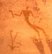
figure 13: chieftain with a mace and a defeated enemy
figure 14: headless beast” devouring a human corpse
figure 15: another “headless beast” to which, inter alia, a human copse is offered in order to be devoured
finis
PS.: In
gratitude for their financial support of the second 4WD trip to the Gilf Kebir
in Winter 2009/10
(lasting from 1/6/2010 to 1/22/2010)
Christian Kny and Christian Philipp share authorship ![]() of this report.
of this report.
To complete this article an appendix containing a summary of relevant 14C datings and their relation to climatic phases etc. will be added soon.
Carlo Bergmann
Sehlis 5/25/2010
PPS.: Text corrections of 5/29/2010 in blue; figure 3 replaced on the same date.
(blue web-addresses ab initio); deleted text marked as ![]() .
.
| Kroepelin's climatic phases | Precipitation | Settlement | Our 14C data from Wadi | Surroundings of the | My C14 data from | Nabta Playa/Gebel | Cronology (see also Barbara Adams; | ||||||
| BP | cal | regime | phases | Sura | Gilf Kebir; van Noten's | Biar Jaqub | Ramlah | Predynastic Egypt, Aylesbury 1988) | |||||
| BC | (Kroepelin) | (Kroepelin) | data in BP-years | ||||||||||
| 9,300 | 8,400 | Hyperatid Climate | |||||||||||
| 2009/10 worked ostrich | |||||||||||||
| egg shell BP 8,935 +/- 50 | |||||||||||||
| Early | WG 32: BP 7,141 +/- 43; | Epi-palaeolithic | |||||||||||
| Holocene | hunter gathe- | BC 6,080-5,920 | (10,000-5,500 BC | ||||||||||
| moderately arid | rers | WG 73/A-5: BP 6,890 +/- | Skel 02: BP 6,685 +/- 45, | 2009/10-39aa: BP 6,640 +/- 30, | |||||||||
| summer rain regime | summer rain | (BC 8,400 - 4,300) | 27; BC 5,790-5,723 | BC 5,640-5,518 | BC 5,618-5,517 | Bashendi A | |||||||
| yielding 100-150 mm | WG73/A-2: BP 6,786 +/- | 2007/08-19: BP 6,492 +/- | 2007/08-37b: BP 6,520 +/- | (BP 7,600-6,800) | |||||||||
| of annual | 28; BC 5,713-5,638 | 35 (BC 5,517-5,372) | 37; BC 5,557-5,378 | ||||||||||
| precipitation and circa | WG 73/A-1: BP 6,300 +/- | 2007/08-39a+b: BP 6,390+/- | |||||||||||
| 4 major rainfall events | 35; BC 5,350-5,210 | 40; BC 5,465-5,313 | |||||||||||
| per century (BP 9,300 - | 2007/08-39c: BP 6,244 +/- | Bashendi B | |||||||||||
| 5,400; calBC 8,400- 4,300) | 35; BC 5,309-5,073 | (BP 6,500-5,200) | |||||||||||
| Pt 24: BP 6,115 +/1 70 | Badarin, | ||||||||||||
| WG 52: BP 5,589 +/- 28 | human skeleton: | Burial 7: BP 5,740 +/- 50 | Fayum A, | ||||||||||
| BC 4,485-4,354 | BP 5,716 +/- 46 | Burial 10: BP 5,610 +/- 45 | Merimde | ||||||||||
| 5,500 | 4,400 | Climattic transition (BP | Burial 3: BP 5,555 +/- 60 | (5,500-4,000 BC) | |||||||||
| 5,400 | 4,300 | 5,400; BC 4,300) | Burial 4: BP5,535 +/- 35 | ||||||||||
| Dune field 2009/10-1 | Sheik Muftah | ||||||||||||
| pastoral | WG 61: BP 5,169 +/- 36; | BP 5,246 +/- 27; BC | (BP 6,000-3,000) | ||||||||||
| Mid Holocene | nomadic econo- | BC 4,050-3,820 | 4,230-3,975 | ||||||||||
| Terminal phase of the | winter rain | mies | CC 41: BP 4,990 +/- 35 | ||||||||||
| Holocene Pluvial | (BC 5,000-3000 | WG 72: BP 4,802 +/- 26; | |||||||||||
| (BP 5,500-4,800; calBC | or, alternatively | BC 3,646-3,525 | |||||||||||
| 4,400-3,500) | BC4,400-3,300) | ||||||||||||
| 4,800 | 3,500 |   |
Naqada 1 | ||||||||||
| 4,500 | 3,200 | 2007/08-27: BP 4,530 +/- 30; | (3,500-3,300 BC) | ||||||||||
| BC 3,360-3,103 | Naqada 2 | ||||||||||||
| extremely arid | 2007/8-46: BP 4,522 +/- 29; | (3,500-3,300 BC) | |||||||||||
| conditions | BC 3,356-3,102 | Naqada 3/Protodynastic | |||||||||||
| PT 43: BP 4,305 +/- 60 | 2007/8-24: BP 4,308 +/- 26; | (3,200-3,050 BC) | |||||||||||
| BC 3,092-2,923 | |||||||||||||
| Dynasties I-II/ Early | |||||||||||||
| Dynastic | |||||||||||||
| (3,050-2,613 BC) | |||||||||||||
| Dynasties III-VI /Old | |||||||||||||
| Kingdom | |||||||||||||
| PT 22: BP 3,510 +/- 35 | 1st Intermediate Period | ||||||||||||
| 2007/08-34: BP 3586 +/- 23; | |||||||||||||
| BC 2,020-1,885 | Middle Kingdom | ||||||||||||
Table 2: Synopsis of the Western Desert climate and settlement phases with a selection of corresponding 14C datings. (Due to imperfections of the Microsoft Word chart programme the formal structure of table 2 including the colouring and the rims of columns, leaves much to be desired. However, after two days of frustration and fiddling around I am now leaving the chart as it is.) inserted on 6/12/2010; corrected on 6/19/2010; additions to the table + corrections of 9/2/2010 in green
Table 2, 5th column, illustrates how the earlier age of the hunter gatherers must have overlapped with the age of pastoral nomads creating a long lasting period of coexistence between these two groups. These groups inhabited southwestern Egypt during the transitional phase between the Early Holocene and the first part of the Mid-Holocene. It is most unlikely that there was an abrupt end to the earlier hunter gathering phase nor a sudden onset of the latter pastoral phase and therefore there was no rigid boundary between these two phases. Indeed, it is also possible that the hunter gathering and pastoral lifestyles were practised contemporaneously by the same group of people over a long period. Undoubtedly, the nature of the environment in southwestern Egypt during the Early Holocene, as reconstructed by Pachur and Altmann, reveals that even quite far into the Mid-Holocene, wildlife was seemingly still available there for the cattle pastoralists that still inhabited the area. (H.-J. Pachur; N. Altmann: Die Ostsahara im Spätquartär. Ökosystemwandel im größten hyperariden Raum der Erde. Berlin, Heidelberg 2006, chapter 4; pers. comm. Prof. H.-J. Pachur )
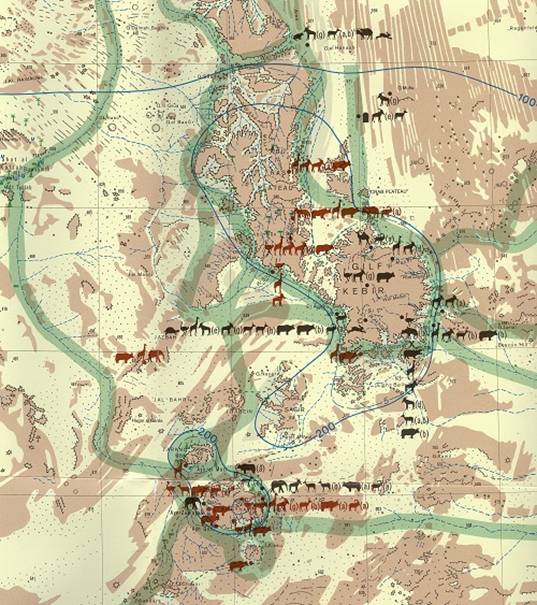
figure 16: detail from H.-J. Pachur; N. Altmann; J. Schulz: “Late Pleistocene-Early
Holocene Fauna in the Eastern Sahara (160 – 28 N, 140 - 310 E)
1: 2,500 000” showing fossil evidence of faunal remains and possible migration routes of the palaeo-fauna in the region of the Gilf Kebir and Gebel Uweinat during the dry phases of the Early Holocene and the first part of the Mid-Holocene (animal figures in black = fossil evidence; animal figures in brown = rock pictures). Courtesy of Prof. Hans-Joachim Pachur. Note that until 2006, no palaeo-faunal remains were discovered in the Wadi Sura area.
With regard to the map shown above in figure 16, this is only part of a much larger map covering the entire expanse between 160 – 28 N and 140 - 310 E. It presents fossil evidence of animal species such as tortoises (Testudinidae), ostriches, giraffes, a wide variety of antelopes, wild cattle, Barbary sheep and hares. According to the authors, wild cattle in particular, were common throughout the area under investigation (that is, between 160 – 28 N and 140 - 310 E), from the Early to the Mid-Holocene. (Ibidem, p. 508) However, the occurrence of wild cattle in the region of the Gilf Kebir has not yet been confirmed by faunal remains. In this context Pachur and Altmann assume that the offspring of wild cattle which were captured, may have been reared and fattened by Neolithic man as was the custom in Pharaonic times with regard to various animal species. It is therefore likely that in the Neolithic period, such practises gave rise to the domestication of wild cattle as well as of giraffes and other ungulates. (Ibidem)
Concerning the hunting of giraffes the reader may be referred to the only known panel of rock art that depicts the hunting of such animals in Biar Jaqub (figure 17). This panel which was discovered by me is dated to the period between circa 5,150 and 4,650 calBC (Mid Holocene. See Results of winter expeditions 2007/8; Preliminary report on the results of radiocarbon- and thermoluminescense (TL)-datings including “On the origins of the hieroglyphic script”, on this website).
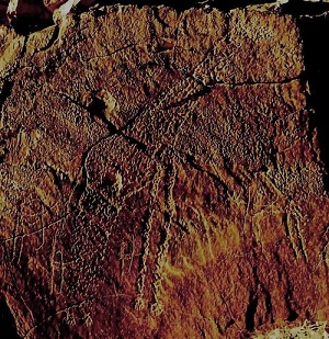
figure 17: self-portrait of the Giraffe Hunters of
Biar Jaqub engaged in a hunt
(colour enhanced)
The very fact that the artists chose to portray the giraffe hunting scene shown in figure 17 suggests that this activity must have been an event of considerable relevance in their lives. It is also clear from modern parallel practises that the event depicted is autobiographical. Note for instance that three of the hunters who are approaching the giraffe from behind, seem to be deliberately aiming their arrows at the legs of the animal. Such hunting practises closely resemble ethnological evidence from South-Western Sudan where the Humr, a cattle keeping tribe, are known to have jabbed the hind legs of giraffes with spears during chases performed by men mounted on horses. “One powerful jab is sufficient. The giraffe spills blood, slows down and comes to a stop… As the giraffe weakens it turns and sways, and may kick out with its front legs. The hunter takes his spear and… kills it by spearing in the throat.” (I. Cunnison, Giraffe hunting among the Humr tribe. Sudan Notes and Records 39 (1958), p. 53) Remarkably, the single hunter positioned in front of the giraffe is shown at a greater distance from the animal than his hunting comrades, as if to avoid front kicks from the weakened beast before the final slaying. Thus regarding the depictions of giraffes in Biar Jaqub, the hunting scene in question is much closer to reality than some rock art specialists would assume. Furthermore, the ethnological evidence from South-Western Sudan seemingly supports the supposition that cattle herding went hand in hand with hunting in Neolithic times. That efforts were made to domesticate calfs of the killed giraffes is proved by figures 18 + 19.

figures 18 (vicinity of Kharga) + 19 (100 kilometres south of Dakhla) :
man holding a rope that is tied to a giraffe´s neck
Carlo Bergmann
Sehlis 6/8/2010
On August 7th 2010 I received the dating results covering three samples of organic material that had been collected from different locations in the wider surroundings of the Gilf Kebir and another from Biar Jaqub. These dates which will shortly be inserted into Table 2 above, are briefly discussed here.
1. 14C dates from localities surrounding the Gilf Kebir
1.1 2009/10 Skel 02
2009/10 Skel 02 consists of several bone fragments from a giraffe, some of them quite large, which were found in the midst of an area that had been occupied in Neolithic times; the settlement being situated in the outskirts of the Great Sand Sea approximately 190 kilometres north of Wadi Sura. The bone remains at the site give the impression they had been chopped up just beside a hearth or in its immediate vicinity. Perhaps the animal was hunted down and dismembered at a distance and only parts of it butchered at the site.


figure 20: eastern end of 2009/10 Skel 02, view to the southeast
figure 21: one of five larger giraffe bone fragments

figures 22 + 23: stone implements in the immediate (southern) surrounding of 2009/10 Skel 02

figure 24: fragment of a giraffe bone used for 14C testing
Due to the lack of sufficient collagen, bone phosphate (German: Knochenapatit) was used for the dating. Despite some uncertainties resulting from a process of diagenetic recrystallization which occurred over the several thousands of years whilst the bones had been embedded in the ground under unknown conditions, which may either have stimulated the generation of additional apatite or the reverse, leading to the chemical precipitation of calcium carbonate, that could also contain extrinsic carbon (German: Fremdkohlenstoff) that would distort the measured result, the dating, as confirmed by a check measurement in Biar Jaqub (see chapter 2 below), most probably is valid within a range of 250 years, that is, the real age of the bones could be up to a quarter of a millennia older. For our purpose such an inaccuracy is tolerable.
2009/10 Skel 02 yielded an age of BP 6,685 +45/-40 (calBC 5,640 – 5,518). Thus, the find is more or less contemporaneous with WG 73/A-5 (BP 6,890 +/- 27; calBC 5,790 – 5,723) and WG 73/A-2 (BP 6,786 +/- 28 (calBC 5,713 – 5,638). The date also fits well into Kuper and Kroepelin’s “Formation Phase” for which the authors present a number of radiocarbon dates derived from charcoal samples which were collected also in the Great Sand Sea. Unfortunately, in their paper, the approximate locations of these finds are not revealed, a fact that makes comparisons and further analysis difficult. (see R. Kuper; S. Kroepelin: Climate controlled Holocene occupation in the Sahara: Motor of Africa’ s evolution. Science 313 (2006), p. 803 et seq.)
Addition to the text of 9/12/2010
Although Kuper and Kröpelin´s supporting online material to their paper entitled “Climate-controlled Holocene occupation in the Sahara”, op. cit. (which material I was not aware of when I originally wrote this article) provides, in table S1, more than 460 radiocarbon dates sorted by regions, among them twelve 14C dates from the Libyan Desert “Glass Area”, additional data and clearer presentation are needed to evaluate these results. Data analysis, is for instance, complicated by the fact that the information submitted in table S1 is denoted with Laboratory Codes, whilst the same data in fig. S1 is presented by Site-ID numbers thus, it is not possible to ascertain which of the laboratory code data corresponds with which Site ID data. Such presentation causes unnecessary confusion and may induce readers to accept, rather than to critically evaluate what has been submitted by the two authors. Thus, for the time being, we can only acquiesce to Kuper and Kröpelin´s findings without being able to properly check them and must assume that the results they obtained during the past 27 years of archaeological work are correct. (It seems unlikely that their endeavors remained error free during such a long period of time.) Hence, regarding the 14C date of the worked ostrich eggshell in the silica glass area (see chapter 1.3 below), it only can be said that this find is slightly older than the oldest of Kupers “Glass Area”-dates (KN 3102 yielding BP 8,860 +/-50).
In the section of their “table” that concerns the area and age in question, Kuper and Kroepelin describe the era by the title “Multiresource Pastoralism” but provide no evidence for either pastoralist or for other activities such as hunting. The bone fragments we have just dated thus help to fill in this gap as the find verifies that giraffe hunting actually took place in the southern part of the Great Sand Sea during the said period.
Comparing the age of the giraffe bones (BP 6,685) we found which were located at quite a distance from the Cave of the Swimmers, with the age of the hearth in Wadi Sura (WG 73/A-5 + A-2 (BP 6,890 and BP 6,786)), it becomes clear that giraffe hunts were performed in the wider surroundings of the Gilf Kebir as well as further north at the same time that Wadi Sura was occupied. Thus, at a time and in a region that was not supposed to have been climatically favorable in terms of rain, as much as the “hilly flanks” on the western side of the huge Gilf Kebir plateau, human activities were still in evidence. But what about giraffe hunting in the immediate surroundings of Wadi Sura proper? Was this also taking place at the same time? To the best of my knowledge there is as yet no evidence for such activities. Thus at present, Pachur, Altmann and Schulz’ map which indicates a potential migration route for big game along the foot of the western escarpment during the dry phases (see figure 16 above) and the depictions of giraffes in the Wadi Sura rock shelters are the only indications that suggest such hunting at close distance to WG 73/A-5 + A-2.
Sidenote 1: WG 73/A-5. For unknown reasons this sample was age-tested again by the 14-C test institute. This control test brought to light a slightly older dating of BP 6,935 +/- 50 (calBC 5,840 – 5,724). This (new) age value further confirms that WG 73/A-2 and WG 73/A-5 are of truly different age thus representing either a continuous use during this span of time or two(?) different periods of occupation.
Sidenote 2: 2009/10 Skel 02 can be chronologically associated with the “phase Gilf B” period lasting from 6,800 to 4,300 calBC during which time according to Linstaetter, hunter-gatheres roamed the area. According to the author, their interregional contacts by far exceeded the Mesolithic (epipalaeolithic) range of exchanges characteristic of “phase Gilf A” (see sidenote 4). The “phase Gilf B” contacts encompassed areas such as the southern Great Sand Sea, southern Egypt, Wadi Shaw and the Selima Sandsheet. (J. Linstaedter: Rocky islands within an ocean of sand – archaeology of the GebelUweinat/Gilf Kebir region, eastern Sahara, in O. Bubenzr, A. Bolten, F. Darius (eds.): Atlas of cultural and environmental change in Arid Africa. Cologne 2007, p.36)
1. 2 CC41 (Andras Zboray classification) - ostrich eggshells
During a survey in 2008 Christian Kny and Mahmoud Marai discovered pottery fragments at the foot of a hill (CC41) which, also embellished with a few rock carvings, is situated half way between the cave discovered by Mark Borda (CC-21; Andras Zboray classification) and Gebel Uweinat. Shortly after this discovery, on the 2/18/2008, both men were arrested in Karkur Talh by SLA (Sudan Liberation Army) – militia who took them as well as a driver and the accompanying Egyptian officer to a military camp deep in the Sudan. This incident caused the end of their 2008-exploration efforts.
Even though the pottery found at CC41 which Christian Kny presented to me in summer 2008, bears no resemblance with the 6th dynasty pottery scattered on the RYT (Road to Yam and Tekhebet; formerly named Abu Ballas Trail), it had become plausible from my calculations that CC41 could have served as a Muhattah (waystation) on this pharaonic trail. Moreover, the site could have been a place where followers and staff of the ancient oasis governor who resided in Balat/Dakhla Oasis, were meeting an indigenous Neolithic population occupying this region. My hypothesis that such gatherings had taken place seems to be supported by van Noten’s occupation age data (PT 22, ostrich eggshell: BP 3,510 +/- 35 roughly equivalent to 2,000 BC (my estimate). See table 2 above.) which however, refers to a site much closer to Gebel Uweinat. Thus, if the concurrence of Neolithic occupation north of Gebel Uweinat and pharaonic visits as described above could be proved, we have an explanation as to why, a long stretch of the RYT, has until now not produced any remains of 6th dyn. (or later pharaonic) pottery. That is to say, it was not necessary to carry Dakhla made jars for the purpose of storing food, feed and water so far to the south as there were locals settled in the region, from whom in case of need, the pharaonic donkey caravans were able to obtain the supplies they required. (It is also possible that this region was wetter in Pharaonic times than areas at higher latitude enabling the Egyptian caravans to exploit water and other resources from the landscape without the help of any locals.)
Remark on the reservoir age of ostrich eggshells:
With regard to my estimate of BC 2,000 (for Pt 22) caution should be exercised. As already stated in my “2007/08 Preliminary report on the results of Radiocarbon- and Thermoluminescence (TL)-datings” it was found that, the reservoir age of ostrich eggshells collected in the Nubian Sandstone environment of the Libyan Desert may amount to circa 400 years. (For an explanation of the reservoir age effect see for instance “Radiocarbon dating” in wikipedia; for details see Vogel et al in: Radiocarbon 43 (2001) pp. 133-137 or www.C14archaeology.ethz.ch/ProgramAbstractsMarch14.pdf) This effect would cause the calBC date of PT 22 to appear about 400 years older than it actually is.) Is this why van Noten rated the PT 22-BP date of 3,510 +/- 35 to calBC 1,530 +/- 35? (F. van Noten: op. cit., p.29)
In Nov. 2009, Uwe George, Uwe Karstens, Dominik Stehle, Khaled Khalifa and his team and myself arrived at CC41 (figure 25). An examination of the site led to Dominik´s discovery of pottery fragments and ostrich egg shells which he found on a terrace extending in front of a sizable rock shelter (figure 26) that is sparsely decorated with a few badly eroded giraffe carvings. (figure 27) As ostriches would not mount the steep rocky slopes of a big hill to lay their eggs, these egg shells provide evidence of human occupation on that elevation. The egg shells were dated to BP 4,990 +/- 35. This date value is rated to BC 3,700. (My estimate. Due to the lack of other datable material from the same site such as charcoal, the reservoir age effect cannot be exactly determined. However, as outlined above this effect may cause the estimated BC-age of 3,700 to appear about 400 years older than it actually is.)


figure 25: CC41 seen from the southeast (courtesy Dominik Stehle)
figure 26: CC 41; rock shelter and terrace circa 8 metres above the ground scattered with
ostrich egg shells and a few pot sherds

figure 27: rock carvings of giraffes at the eastern side of a prominent CC41-shelter
situated circa 10 metres above the ground
The ostrich eggshell date obtained from CC41 is fairly contemporaneous with the occupation date from WG 72 (wooden peg from the roof of the Cave of the Swimmers which yielded an age of BP 4,802 +/- 26; calBC 3,646 - 3,525) thus, as explained above, this indicates the latter´s use by hunter-gatherers or more probably, cattle pastoralists of the western Gilf region. The sizable amount of pot sherds of different types and designs seen at the foot of CC41 and at the neighboring hill suggests that, over an unknown period of time, the site was continually inhabited by a populace probably involved in the same activities as those common to the inhabitants of Wadi Sura. No cattle images were found.
A number of rock paintings seen, for instance, at the Borda Cave (figures 28 – 31) and at several sites at Gebel Uweinat (eg. site KG 1) indicate that, cattle herding and hunting (of giraffe) may have accompanied each other. It is therefore impossible to draw a distinct line between the so called hunting/gathering- and the cattle herding period. (see also sidenote 4.)
- Although actual giraffe hunts are not depicted in the Borda Cave it seems clear that the bowmen of that period either participated in protecting the herds or were engaged in hunting activities and/or warfare. Note that at the back of the Borda Cave there are some faint engraved lines which possibly represent a giraffe. (see M. Borda: A remarkable rock art shelter between Gilf Kebir and Uweinat. Sahara 19 (2008), p. 148))
- Site KG 1: Painted panel in the Giraffe Cave depicting giraffe, cattle, a homestead scene and bowmen. This magnificent piece of rock art reveals that giraffe were present in the prehistoric grazing grounds at the time the panel was painted and that the cattle herders at Gebel Uweinat may have also hunted giraffe by means of archery. See A. M. Noguera et al: New rock art sites in the southwestern sector of Jebel Uweinat (Libya). Sahara 16 (2005) Pl. A + B)


figure 28: CC 21 (Borda Cave); cattle pastoralists and their herd (courtesy of Andras Zboray:
Rock Art of the Libyan Desert. 2nd edition, Newbury 2009)
figure 29: CC 21; Bowman of the cattle pastoralist era carrying white arrows in his right hand;
bow completely faded. (courtesy of Andras Zboray; ibidem)
figures 30 + 31: CC 21; two bowmen from the cattle pastoralist era. (Courtesy of Andras Sporay; ibidem)
1. 3 2009/10 worked ostrich egg shell (silica glass area)
This peculiar item (figure 32) was still in one piece when discovered on the 11/20/2009 by Uwe Karstens. Before it broke apart, it represented a three pointed star displaying clear sings of bevelling at its edges. Although two fragments of the artefact got lost, there is no doubt that the object is man-made. Despite the lack of a pinhole, it seems it was an amulet or a piece of jewelry used for some kind of adornment or ornamentation. In connection with the issue of the mythical-religious or magical character of the odd numbers ‘five’ and ‘seven’ observed on an engraving at the Foggini-Mestakawi Cave (see main report and sidenote 4 below) it seemed appropriate to ascertain the age of this three pointed item to see if its age also fell within the same period.

figure 32: former three pointed star carved out of an ostrich egg shell
The radiocarbon measurement of this three pointed artefact revealed an age of BP 8,935 +/- 50 which, as yet, has not been calibrated by the dating institute concerned. My estimate is that the calibration will yield a date roughly equivalent to calBC 7,800. (see however, the reservoir age of ostrich eggshells referred to above) This date by far exceeds the earliest 14C date derived so far from the Wadi Sura area (see WG 32 which dates to BP 7,141 +/- 43; calBC 6,080 – 5,920) i.e., the date is almost 1,800 BP-years older. Because of the noticeable difference in time and the spatial separation of about 180 km (i.e., between the site where the three pointed star was found and the Wadi Sura region), it seems, prima facie, that there is not sufficient basis to establish a link between the two dates that might indicate a cultural connection (in terms of the use and meaning of “sacred numbers”) between the two peoples concerned.
However, such an assertion may be weakened by the find of a piece of jewelry made out of a tiny pebble formed into a pentagon. Into both sides of this item a five pointed star had been carved. (figures 33 + 34) The pebble which is only 6.8 millimetres in diameter, comes from the same site as the three pointed star. Does this at least imply that the number ‘five’ already had a mythical-religious significance before the Neolithic, its prevalence reaching as far back as the Mesolithic? Or, should we consider the occurrence of these possible “sacred” numbers (i.e., ciphers three, five and seven) in the decorative art of the Western desert as merely accidental? (Decorative art is viewed here as an important cultural component of pre-historic societies, providing a medium for communication of symbolic meaning. In this context the existence of amulets and charms should not be interpreted as childish reverence of these peoples to various superstitions that were passed through the times to the ancient Egyptians, but considered as a chief source of information.) Given the small data base which I currently have at hand, it is too early to decide this issue.


figures 33 + 34: small pebble formed into a pentagon into which, on either side,
a five pointed star has been carved
Sidenote 3: The two finds fall well into Kuper and Kroepelin’s “Reoccupation Phase” (BC 8,500 – 7,000) which started ‘…with surprisingly early settlement in the Egyptian Sahara…’ (R. Kuper; S. Kroepelin: op. cit., p. 803 et seq.). With regard to the Great Sand Sea and the period in question, Kuper and Kroepelin present a number of radiocarbon dates which were derived from charcoal samples, a single one being obtained from bone. (Ibidem) Sadly again, the approximate location of these finds is not revealed in their paper. This practise (of monopolizing information) does not favour independent assessment and makes further analysis difficult if not impossible. (See however, text addition of 9/12/2010 above)
Sidenote 4: Note that, according to Linstaedter, around calBC 8,300 (during the Epipalaeolithic phase of Gilf A) the hunter-gatherers of that area were linked by interregional contacts (reconstructed on the basis of stone tool distribution) to regions such as southern Egypt (Note also that cattle bones found at Nabta Playa and dated to the ninth millennium BC (the so called “era of early pastoralists”) prove that “…nomadic pastoralism and …(the) keeping of herds of cattle as treasured and much needed source of proteins, milk and blood“ (M. Barta, M. Frouz: Swimmers in the sand. Dryada 2010, p. 77) was common already in the epoch of hunter gatherers.), the Great Sand Sea and the Quattara depression placing “...the Gilf Kebir at that time in a context of more than 400,000 km2.” (J. Linstaedter, op. cit., p. 36) These contacts certainly were not limited to the traffic of goods as for instance demonstrated be the seemingly wide spread distribution of ‘sacred numbers’. Thus, the question of cultural communication and the exchange of ideas has also to be raised.
According to Morenz “… the emergence of culture from religion is one of the basic trends of historical development”. (S. Morenz: Egyptian religion. op. cit., p. 13) Therefore, the notion that numbers derived from religious concepts may have existed in prehistoric times is not as absurd as it might sound at first. To examine this particular issue within the context of the above finds as well as with regard to the new insights gained from the Foggini-Mestekawi Cave, seems reasonable as there are now indications that the “ars sacra” of the Western Desert Prehistoric may partly, have set the tone for some of the religious concepts of ancient Egypt. If we envision the pebble shown in figures 33 + 34 as a charm which, already in late epipalaeolithic times, was turned into an amulet by decorating it with a five pointed star on either side, the time-limit since “…recognizable types of amulets were being made…” (I. Shaw; P. Nicholson: The illustrated dictionary of ancient Egypt. Cairo 2008, p. 32) and which so far, has been established in the Badarian period (5.500 – 4000 BC; ibidem p. 32 et seq.), has to be shifted much further into the past. Thus, in the light of the results presented in this paper it seems justified to consider the period around 8,000 – 7,500 BC as one of the formative stages that, already by that time, foreshadows aspects of the much later Egyptian magic and religion. Evidently, at this early stage a stellar cult had developed who´s origins might go back even further in time (The belief system of the early prehistoric dwellers of the Western Desert may well, in parts, have been imported from other African regions around 8,500 BC, at the beginning of Kuper and Kroepelin´s “Reoccupation Phase”, when hunter gatherers entered the area from the south bringing their established social ideas and concepts of the sacred as well as their material culture such as the techniques of pottery production which hitherto were not known in the Western Desert. Thus, if the star images presented here are not merely tribal marks (wasms) but instead, signify manifestations of the divine in some way, they represent a significant stage in the development of religion, as the idea that the divine might be manifest in celestial form is a vital prerequisite for any stellar cult whose main function was to reconcile man with its own mortality. Undoubtedly, such a cult would have been deeply rooted in everyday life as the “..priority of observing the night sky and the movement of the principal constellations is quite typical for all African tribal societies; whereas the solar aspects of Nabta Playa embodied in the solar calendar is quite exceptional and ushers in a later dynastic tradition of solar cult so typical for ancient Egyptian civilization.” (M. Barta: Swimmers, op. cit., p. 87)) Note that much later, zoomorphic images are shown acting as divine astral beings in representations of gods in the dynastic period (Such as Nut, the goddess of the sky, seen as an anthropomorphic form of the Milky Way (Ibidem, p. 51) or as a celestial cow, her “..body painted black or yellow as the night sky and covered with yellow stars”. (Ibidem, p. 57) This later stellar imagery of Nut was used elsewhere to show her as swallowing the sun disc similar to the devouring of people by the “headless beasts” who as gods of the caverns swallowed “swimmers” (Ibidem, p. 62) in the period around 6,000 BC.) However, note also that, as the early gods depicted in the Foggini-Mestakawi “…go back to dimly distant prehistoric times which may lie forever beyond our grasp in terms of any full degree of understanding…” (R. H. Wilkinson: op. cit., p. 10), the idea that images such as stars or “headless beasts” actually reflect a belief in a divine being or beings may still be questioned. Yet the care with which they were engraved or painted during the period in question suggests that the necessary intellectual sophistication was present for such belief. (ibidem))
In the earliest beginnings, the use of star motifs may indicate that the corresponding amulets “…were worn in daily life in order to protect the bearer magically from the dangers and crisis that might threaten him or her…” (I. Shaw; P. Nicholson: op. cit., p. 33) as was the custom with regard to other motifs in the much later dynastic times. The star images shown in figures 32 - 34 also suggest that prehistoric peoples who dwelt in what is now the Western Desert “…seem to have been reverential towards the powers of the natural world (probably) both animate and inanimate.” (R. H. Wilkinson: op. cit., p.12; for an example of the former see figure 35) But, notwithstanding a few exceptions, because of the (general) absence of domestic animals and cattle raising during the hunter gatherer period, these early dwellers may have been much more disposed towards worshipping the inanimate. Such a psychic predisposition brings such stellar cults, as indicated by the above finds, into the realm of possibility. (Recurrent star images found on the Gerzeh Palette from the Nile valley and other artefacts from the later Neolithic Period (3600-3300 BC) may indeed echo the remnants of stellar cults that had existed throughout the Western Desert long before Pharaonic times, Egyptian statehood and the invention of writing. Thus the genesis of the Egyptian gods may go further back in time than Egyptologists have envisaged.)

figure 35: an early zoomorphic(?) image (RHS) possibly representing the divine
(The shape of the artefact seems to bear some resemblance
to zoomorphic shaped grinding stones found in the central
Sahara. Such a grinding stone discovered at Jabbaren,
was dated to 3,550/2,500 BC. See J. L. Le Quellec:
A propos des molettes zoomorphes du Sahara central.
Sahara 19 (2008) p. 41)
“What, then, existed before God? Theologians generally refer to it as ´power´…. Power…forms the basis of worship… everything can in principle be God, from an inanimate implement or object, a plant or animal, to an individual human being… The simple concept of power, for which one may substitute ´efficacy´.” (S. Morenz: op. cit, p. 17 et seq.)
The efficacy referred to by Morenz, is seemingly exemplified by the “headless beasts” devouring persons from one side and disgorging them from the other. Thus ´efficacy´ “…may serve as a common denominator for the immense variety of cult objects…” (ibidem, p. 18) that were believed to be charged with this elemental force that “radiated” supernatural power to believers, and that finally acquired a religious meaning which later in the Neolithic period, when a formalization of religious rituals may have occurred, was incorporated into religious concepts by an emerging priesthood.
Sidenote 5: In ancient Egypt, according to Wilkinson, the “ ..most commonly used sign for god…which (is) … very ancient, resembles in its developed form a flag atop a pole… (as) the symbol of divine presence which fronted Egyptian temples and shrines back to prehistoric times… Very late in Egyptian history the hieroglyph of a star… could also be used to write the word god, but this is found only from the Ptolemaic Period on.” (R. H. Wilkinson: op. cit., p. 27) From the latter period five pointed star decorations were found painted on an ostrich egg shell and on the bottom of a terracotta lamp. Both items were unearthed at the Ptolemaic-Roman port of Berenike. (see S. E. Sidebotham, I. Zych: Berenike: Archaeological fieldwork at a Ptolemaic-Roman port on the Read sea coast of Egypt 2008-2010. Sahara 21 (2010) p. 19, fig. 41)
2. a 14C dating from Biar Jaqub
In my previous posting (Results of Winter 2007/08 expedition; Preliminary report on the results of Radiocarbon- and TL-datings, 6th amendment) the 14C date of an animal bone found embedded in the sediment of a prehistoric fire place at Biar Jaqub was published. The skeletal fragment (2007/8-39a) was dated to BP 6,390 +/- 40 (calBC 5,465 – 5,313). Because of low collagen concentration in the skeletal remains, bone apatite CO2 was used for radiocarbon dating which was done by AMS (accelerator mass spectrometry). As extraneous carbonates can attach to the bone apatite and as soil carbon can exchange with bone carbon during diagonesis, a margin of error had to be factored into the resulting radiocarbon date of the bone sample submitted. Therefore, it seemed important to contrast the above age determination with a charcoal sample from the same site.
The fire place in question indeed contained a small amount of charcoal (2009/10-39aa) which, thanks to a financial contribution of my dear friend Hardy Boeckli, was recently 14C-dated to BP 6,640 +/- 30 (calBC 5,618 - 5,517) thus, exposing an age which is 249 +/- 50 14C years older than the bone apatite. According to the expert in charge of both tests this age divergence could have been caused by younger impurities contaminating the dated bone apatite. Other explanations are a.) The bones were dropped into the hot hearth and thus, their chemical properties were changed by the extreme heat. Hence, the action of heat possibly caused a corruption of the bone sample´s age. b.) The bones were deposited at the hearth 250 years after the last fire had died. c.) unrecognized stratigraphy of the hearth d.) measuring error.
Carlo Bergmann
Sliema (Malta) 8/12/2010
posted on this website 9/1/2010
additions to the text + corrections of 9/2/2010 in green
Author´s notice concerning Andras Zboray´s comments on the finds presented in chapter 1.3 above
Regarding figures 33 + 34:´pebble with a star´(see chapter 1.3 above) Andras Zboray emailed (on September 7 and September 13): “The object … is a fossil crinoid (sea lily) stem segment; it is not man made. It is Cretaceous or earlier … If you ever find anything with fivefold symmetry then a fossil echinoid should be the primary suspect… The find is quite interesting by itself. I have not seen anything the like in the Western Desert. (See more on these fossils here: http://www.chalk.discoveringfossils.co.uk/3isocrinids.htm)
Even if Andras is right, there still remains the fact that the pebble was found in the debris of a Neolithic site. I wonder about the circumstances surrounding the finding of this pebble. It evokes in me a vision of an ancient desert dweller, picking up from the ground and bringing to his camp this star shaped object which he might have regarded as a star fallen from the sky. Did prehistoric desert dwellers intentionally collect such tiny objects because they were valued as pieces of jewelry? Or did they feel attracted by the pentagonal body plan of such crinoid stem segments so that, subsequently and as a consequence of their interest, at some point in time, a meaning became attached to them? Although the link above does not show silicified samples but rather, soft chalk fossils of a different design, it seems quite remarkable that no other similar fossils, as those embellished with a five pointed star seen during our expedition, have as yet been found in the northern vicinity of the Gilf Kebir.
Sidenote 6:
How ancient Egyptians perceived objects that, in their view, because of
peculiarities in shape possessed a symbolism or a magical function, is indicated
by an inscription “… made at the command of the pharaoh Thutmose IV
(1,401 – 1,391 BC; that)
records the discovery by the king of a stone. The significance of this
celebrated stone lay not in its being of rare material…, the inscription tells
us, but because ´his majesty found this stone in the shape of divine hawk.´ That
an Egyptian king should place so much importance on a mere rock simply because
of its shape is instructive, for it shows how alert the ancient Egyptian was to
the shape of objects, and to the symbolic importance which the dimension of form
could hold.”
(R. H. Wilkinson: Symbol & magic in Egyptian art. London 1994, p. 16)
The fact that, in dynastic times naturally shaped
items were believed to possess symbolic significance and therefore, were
considered highly attractive sheds light on the way how, in the
Neolithic period, desert dwellers may have esteemed objects such as the
pentagonal pebble embellished with a five-pointed star.
(sidenote added on 11/1/2010)
Regarding figure 32 above Andras notes that “…the triangular object… looks.. like a ventifact (wind shaped object; German: Windkanter ), rather than man made.” He continues: “It is amazing what wind blown sand can do over thousands of years. The shape suggests that there were three stable seasonal wind regimes during its formation… The shell is both relatively soft, and very brittle when thin. I cannot readily see any use for such an edge if it were man made (practically all man-shaped ostrich shell-fragments I have seen have a clean thick edge). Same applies to figure 35 (right), the edges there are clearly wind eroded.”
How long would it take to grind out a three pointed star from an ostrich egg shell by natural forces? To my knowledge it is unlikely that multidirectional wind regimes capable of creating an extremely regular configuration such as the three pointed star shown in figure 32, had ever existed in the Silica Glass area. Leaving aside for a moment this tiny artifact and focusing instead on large-scale natural phenomena, it is known that, in other areas of the Sahara, huge star dunes are created by multidirectional wind regimes. In some cases these “…pyramidal sand mounts with slip faces on three or more arms that radiate from the high center of the mound” (http://en.wikipedia.org/wiki/Dune#Star) are built quite symmetrically. Would the occurrence of symmetrically shaped ostrich eggshell ventifacts therefore, be more likely in areas where star dunes occur?
As the three pointed star (figure 32) was destroyed when 14C tested, there is no way to review my findings. However, in the case of the animal shaped ostrich egg shell shown in figure 35 such a re-examination is possible. Contrary to Andras´ assessment the polished edges are not at all brittle. Instead, they are unexpectedly robust and resilient. Could the item have been used as a small tool whose edges were whetted on both sides? In order to sharpen the implement?
FINIS
Carlo Bergmann
Sehlis 9/28/2010
(in preparation)